Symonds Yat and Goodrich Castle
2 May 2012
The Malvern U3A Geology group visited both Symonds Yat and Goodrich Castle on Wednesday 2 May 2012. This visit was led by Elizabeth Staley, with preparation help from Mary Geffen.
Much of the material used on this excursion was provided by the Landscape and Geology Trail 'Symonds Yat', and the Building Stones Trail 'Goodrich Castle', both published by the Herefordshire and Worcestershire RIGS Group (now the Herefordshire and Worcestershire Earth Heritage Trust) . The Earth Heritage Trust trail guides can be purchased from Herefordshire and Worcestershire Earth Heritage Trust; Geological Records Centre; University of Worcester; Henwick Grove; Worcester WR2 6AJ (01905 855184) ; cost around £2.
Click here for:
A map of
the trail around Symonds Yat
A
geological sketch map of Symonds Yat
A
write-up of the day
Pictures
of the day
Symonds Yat map

Geological sketch map

Geological sketch map of the overall area of interest.
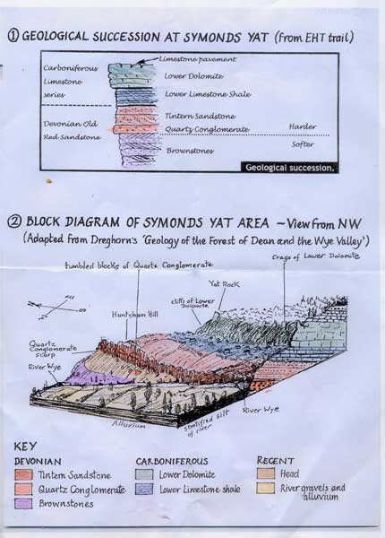
The geological succession, view from NW.
Report of the day (by Elizabeth Staley)
Symonds Yat
This excursion was one of three events which looked at the relationship between the River Wye and the Forest of Dean. The first was Moira Jenkins's talk on 11th April 2012, and the second was a walk in the Wye Gorge near the Biblins on 18th April. On the third event (this visit), we visited Symonds Yat and Goodrich Castle.
The first stop was on the flood plain of the Wye just south of Huntsham Bridge (point 1 on the map above). Here we identified the local hills and saw how the Wye crosses and recrosses the boundary between the softer Lower Devonian rocks lying to the north and west and the harder Upper Devonian and Carboniferous rocks which form the Forest of Dean (see geological sketch map below). We also discussed the features of the flood plain and the slightly higher river terrace.
At the next stop about ¾ of a km. further south along the road, we looked at the blocks used to build the roadside wall of Huntsham Court (point 2 on map). We examined their various textures, colours, bedding and other features, and learnt that they are all local Devonian Old Red Sandstones, varying from fine-textured sandstones to Quartz Conglomerate. These beds were laid down in a semi-desert environment by braided rivers flowing south from new mountains raised in North Wales during the Caledonian orogeny.
From here we could glimpse the Quartz Conglomerate exposures and huge fallen blocks on Coppet Hill and Huntsham Hill. We were to pass this conglomerate bed as we started uphill to Symonds Yat, and also the Tintern Sandstone and Lower Carboniferous limestones (see block diagram). However the narrowness of the road precludes any stops to examine these beds.
We parked at the main Symonds Yat car park (point 3 on map). Here a useful interpretation board helped us to understand how the meandering course of the Wye has been preserved as the Forest of Dean has risen relative to the Hereford Plain and to sea level, resulting in "incised meanders". After noting the Iron Age fortifications across the neck of the Symonds Yat 'promontory', we made a short detour to the west to look down into the steep valley of the Wye and across to the settlement of Symonds Yat West on the lower slopes of Great Doward.
A short walk took us across the promontory to Symonds Yat Rock itself, a magnificent vantage point (point 4 on map). Here the main view is eastward, in contrast to the previous view point. We looked down onto the river which flowed towards us before swinging north into the Huntsham Bridge meander, and at the details of its course in the valley bottom. Symonds Yat rock itself and Coldwell Rocks to the south east (where the peregrines nest) are formed of Lower Dolomite, the hardest crag-forming rock in this locality. The small area of 'pavement' at the viewing point shows clints and grykes, and a clear specimen of fossilized coral.
Goodrich Castle
About 4 kms to the north, overlooking the Wye, is Goodrich Castle which we visited in the afternoon. Most of this magnificent castle was built in the late 13th century, with some later additions. It was badly damaged in the Civil War and probably has not been inhabited since, providing a dramatic ruin for the 19th century Romantic tourists.
It is built mainly of local sandstones. Much of the stone was quarried on site, leaving an impressive dry moat on the south and east sides of the castle where the Brownstone bedrock can be examined. As we looked around the castle we saw different sandstones, varying in texture, colour, bedding and the degree to which they have weathered over the centuries. Two kinds of stone were probably brought from quarries further away: the well-preserved grey stones of the keep, including some conglomerate; and the yellow sandstone used for carved details inside the chapel.
The keep, curtain wall and rooms above the chapel provide extensive views. To the north is Ross-on-Wye and the neighbouring area which we had explored last year. To the south we could see the outlying hills of the Forest of Dean which we had identified in the morning. We could follow the course of the Wye until it disappears below Kerne Bridge to flow behind Coppet Hill.
Pictures of the day
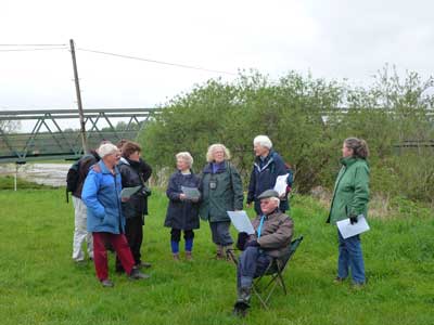
The group at Huntsham Bridge. We are standing on the outer part of the meander of the River Wye, on a floodplain. The bedrock here is Devonian Brownstones.

The wall at Huntsham Court - quartz conglomerate. The white pebbles are quartz, held together with a red sand silica matrix. The pebbles are rounded, showing they have been carried some distance before being deposited.

Symonds Yat, the Peregrines nest on the cliffs to the right of the river. The creation of the meander is quite interesting, involving the erosion of hard rocks where a softer rock is now available. This suggests that the course of the river dates back to the time when the hard rocks covered the whole area.

A coral fossil in the Limestone pavement at the top of Symonds Yat.

Goodrich Castle. Built out of Old Red Sandstones, namely Brownstones (Lower Devonian). These can be seen as bedrock at the foot of the walls, dipping 30 degrees to the east.

The gatehouse at Goodrich Castle. Different types of sandstone are used, indicating changing conditions of deposition.

Thick red sandstone in the gatehouse. This thick layer demonstrates continuous deposition, and created a stronger building stone.
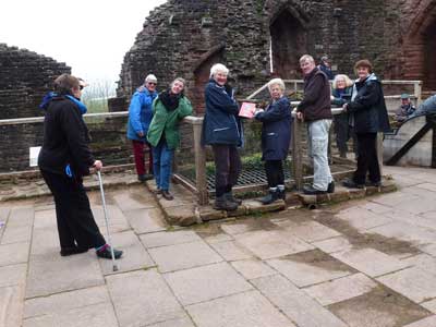
The group by the well, Goodrich Castle.

Example of differential weathering of sandstone beds in the Great Hall, Goodrich Castle. The sandstone blocks have eroded differently, depending on how hard or soft they are. The harder bands contain more large quartz grains.

Bedrock below the South Eastern outer wall of Goodrich Castle. Note the thin and thick sandstone bedding. The thick beds were laid down during a period of continuous deposition. The thin beds represent periods of deposition, punctuated by periods of erosion or non deposition.
To return to home page, click here.